By Benjamin Pollard
How do you prepare for a trip when you don’t really know where you are going or how long you will be gone? This was the daunting question faced by Captains Meriwether Lewis and William Clark as they prepared at Camp River Dubois for their famous expedition. In fact, their time spent in the Illinois Country preparing and training was at least partly responsible for the expedition’s success.
When President Thomas Jefferson and the United States government purchased the Louisiana Purchase from France for $15 million in 1803, it was unclear exactly what was out west. The boundaries of the purchase were not even clearly defined at the time. President Jefferson selected his personal secretary and U.S. Army Captain Meriwether Lewis to lead an expedition of soldiers through the Louisiana Territory. They were tasked with many objectives that can be boiled down into 4 main goals: find a water route up the Missouri River to the Pacific Ocean, meet on a friendly basis with Native American tribes, document the territory with maps and journals, and scientifically study the plants, animals, and minerals of the region. This was much more than a road trip there and back! Lewis realized he needed supplies, soldiers, and a co-captain in his friend William Clark.
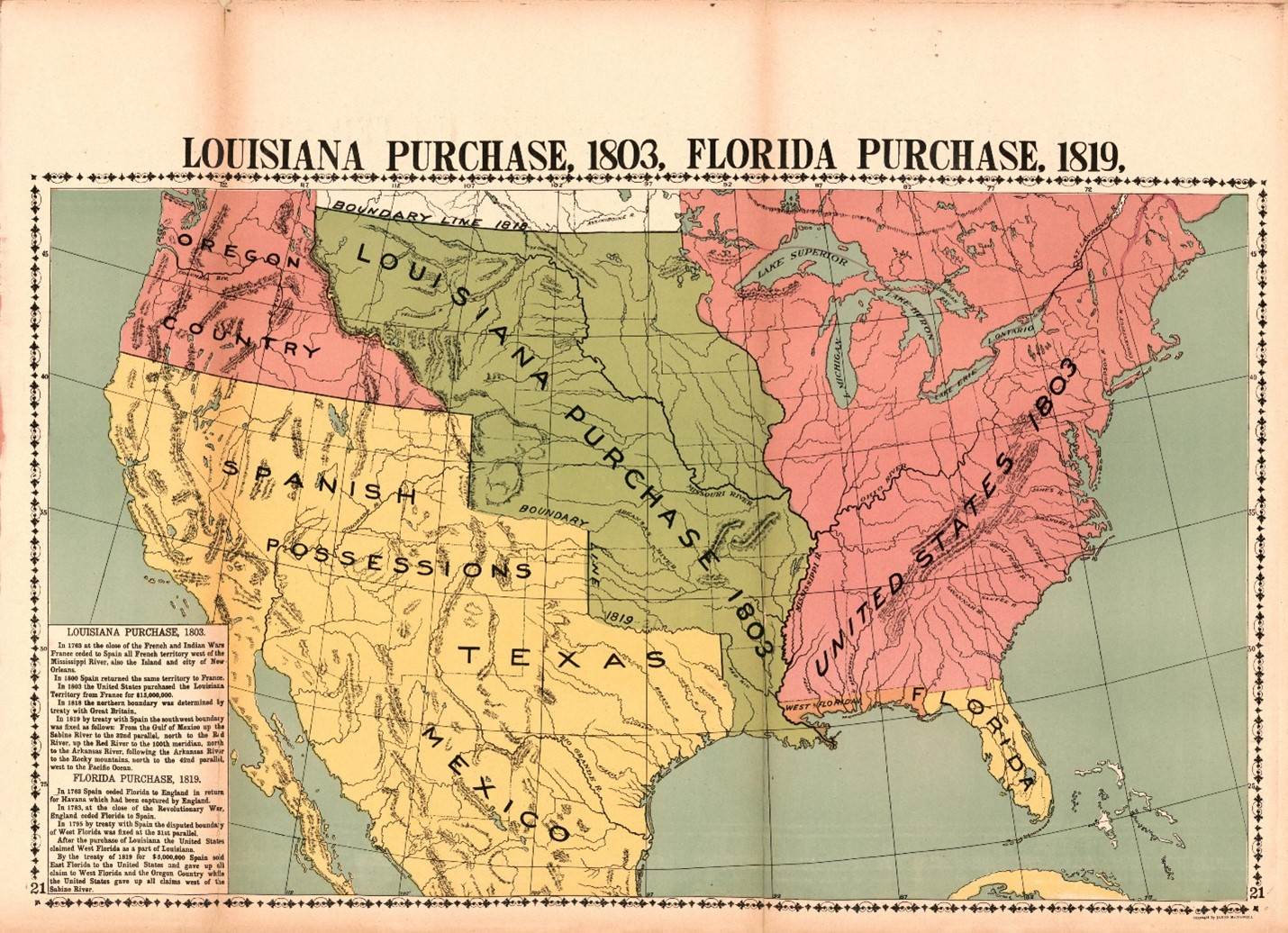 Map from “McConnell's Historical maps of the United States” (Courtesy of the Library of Congress)
Lewis and Clark put an exceptional amount of thought into their endeavor. Lewis purchased trade goods and tools in Philadelphia and Pittsburgh. Clark began to sort through the many young Kentuckians that wanted to enlist for the journey. By the middle of 1803, the expedition began to make its way down the Ohio River eventually towards Cahokia, Ill. Two important Illinois fortifications in Fort Massac (Metropolis) and Kaskaskia (Ellis Grove) provided skilled soldiers with much-needed interpretive, blacksmithing, hunting, and carpentry skills.
While the low water levels made the Ohio River slow going, politics and poor weather stopped the expedition entirely for the winter near the St. Louis/ Cahokia area. The soldiers had to build a winter encampment before the weather worsened. The way into present-day Missouri was shut off as well. Since the Louisiana Purchase had not yet been formally transferred to the United States, Lewis and Clark were forced to encamp east of the Mississippi River. While a frustrating turn of events, this eventually directed them to make a winter encampment called Camp River Dubois at the confluence of the Mississippi and Missouri rivers.
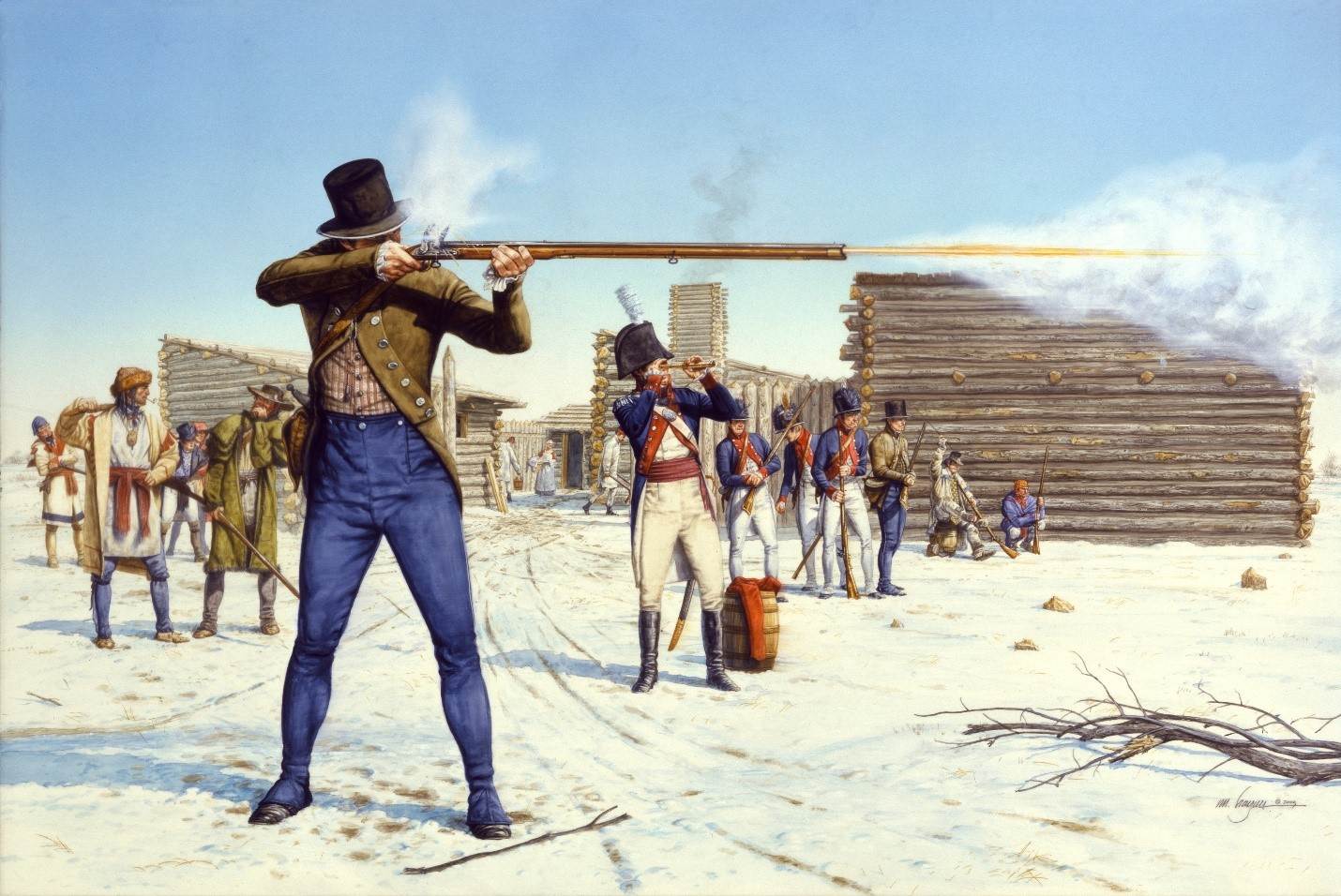 “Shooting for the Red Leggings” by Michael Haynes depicts the Lewis and Clark expedition in Illinois. A reproduction is on display at the ALPLM
Camp River Dubois was removed enough from Cahokia and St. Louis to keep the soldiers from “temptations of the town.” It had ample game for hunting, and it placed them as close to the expedition starting line as possible. The camp also proved a test for the soldiers. They were forced to build a fortification from scratch. A month of labor spent felling trees, dragging them to camp, and building cabins in the December 1803 slushy mud showed the captains which soldiers were worth keeping and whose work ethic was found wanting.
Soldiers in the camp tried to prove their worth by showing off trade skills, language abilities, and knowledge of the rivers. The captains had soldiers try most camp tasks like hunting, guard duty, and cooking to see who excelled in each position. Recruits with the right skill set were welcomed with drill and training to begin building a teamwork mentality that would serve the expedition well.
The expedition’s camp location allowed for gathering information from the locals about what was up the Missouri River. Lewis, Clark, and others questioned Spanish, French, and Native American fur traders with knowledge of tribal nations the expedition would soon encounter. This intelligence gathering gave some idea of what lay ahead. Local businessman John Hay even pre-packed gift boxes of trade goods for the first few dozen tribes that the soldiers should encounter on the river. The goal was to make a good first impression.
Of course, there were practical needs to address in camp as well. The captains projected their food and supply needs for a trip totaling 1.5 years (it was closer to 2.5 years). Tons of salted pork, corn, and flour had to be sorted and packed for a rough journey. Tents, tools, and ammunition were double-checked. Anything missing could usually be purchased in Cahokia or St. Louis, but they were well aware this was the last stop to shop.
With supplies, a newly trained team, and detailed information, the expedition was ready to go. The boats left Camp River Dubois on May 14, 1804. Facing the unknown, the men were likely a mixture of excitement and anxiety. They hoped for amazing experiences to wow folks back home. They hoped to make their young nation proud. They hoped to come back alive. They did not yet know if their preparations would be enough to see them through successfully.
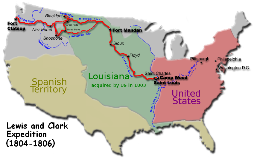 The expedition’s route from Camp River Dubois to Fort Clatsop and back to St. Louis (Map courtesy of Wikimedia Commons)
Lewis & Clark State Historic Site in Hartford, Ill., shares the Lewis and Clark story as the expedition encamped at Camp River Dubois from December 1803 to May 1804. The Interpretive Center has different galleries focused on the expedition’s goals, preparations, time in camp, and the expedition itself. A life-size replica of the expedition’s keelboat gives a sense of the scale of the journey. With plenty of hands-on exhibits, the Interpretive Center offers something for all ages and interests. Pavilions, cabin replicas, and a confluence viewing area round out the site’s offerings.
You can learn more about the expedition by visiting Lewis & Clark State Historic Site or visiting www.CampDubois.com. Right now, you can also see a display about Camp River Dubois at the Abraham Lincoln Presidential Library and Museum.
 Camp River Dubois items on display at the ALPLM until July 27th.
Benjamin Pollard is the site interpretive coordinator at Lewis & Clark State Historic Site.